Course Introduction - I
What are geophysical field methods and how are they applied to geological questions?
An analogy
Think of a field mapping exercise. Although field mapping is of course fun in its own right, it usually is done to help reason about and solve a geologic question — whether it is a pure- or applied-geologic question. For the geologic question in hand, what kind of map do you need to make? Surficial deposits or bedrock? In what detail do you need to map structures? What is the appropriate resolution of your base map?
The purpose of a geophysical field survey is to gain complementary clues into the nature of subsurface geology to help solve a geologic question. But as in the case of the mapping exercise above, the geologic question and the resolution needed will help decide what type of geophysical field survey, and its design, to carry out.
To gain these complementary clues you must first do appropriate geologic reconnaissance and create a preliminary geologic model of the subsurface. The geophysical field survey will be designed against the preliminary geologic model. This doesn't mean your preliminary geologic model is correct (perfectly, partially, or not at all) but you must have something to go on. The geophysical field data then provides clues to complement — not replace — the geologic observations:
Important
You must do your geologic reconnaissance and have some ideas of reasonable preliminary geologic models of the subsurface. This takes experience and geologic judgment.
It is meaningless to process and interpret geophysical data that is divorced from its geologic environment.
What does a geophysical field survey measure?
A working definition: a geophysical field survey — remotely — measures a parameter of the subsurface geologic materials and their state.
The field mapping analogy of course then breaks down: we can't directly observe the subsurface except in outcrops and boreholes, both of which may be quite limited but yet are of critical importance to the interpretation of the geophysical data.
What is meant by a physical parameter of the subsurface?
The density variation in the subsurface ("gravitational methods")
The velocity of elastic wave propagation in the subsurface ("seismic methods")
The electrical conductivity of the subsurface ("electrical methods")
Instead of conductivity we will end up using the term resistivity, but the word conductivity may be more familiar sounding to you at this moment.
Conductivity and resistivity are simply reciprocals of one another.
High conductivity ↔ low resistivity; Low conductivity ↔ high resistivity.
Magnetic properties of the subsurface ("magnetic" methods")
Radioactivity of the subsurface ("radioactive methods")
Others?
Keep in mind these measurements might be made in one-, two-, or even three-dimensions. And with time-lapse surveys, an additional (perhaps fourth) dimension might be added.
What is meant by the state of a geologic material?
We can illustrate the idea of the state of a geologic material with some examples:
Think of a groundwater aquifer: an elastic wave traveling through the unsaturated portion will travel at a different speed than through the saturated portion — even though it is the same geologic material. In a similar way, the electrical conductivity of the unsaturated vs. saturated material will be distinct.
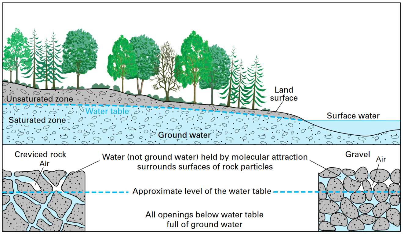
Unsaturated and saturated zones of an unconfined groundwater aquifer. Image from the USGS website.
A common conceptual model of a hard-rock granitic aquifer (Lachassagne et al., 2011) contains three primary layers (see image below): (1) a weathered or decomposed granitic layer (containing clay derived from the feldspar minerals), (2) a fractured layer which may be permeable if the fractures are sufficiently connected (and not filled with clay), and (3) a competent or unweathered hardrock granite layer. Each of these layers would exhibit distinct values of seismic wave velocity with depth, as well as distinct values of electrical conductivity with depth as the physical state of the geologic material changes.
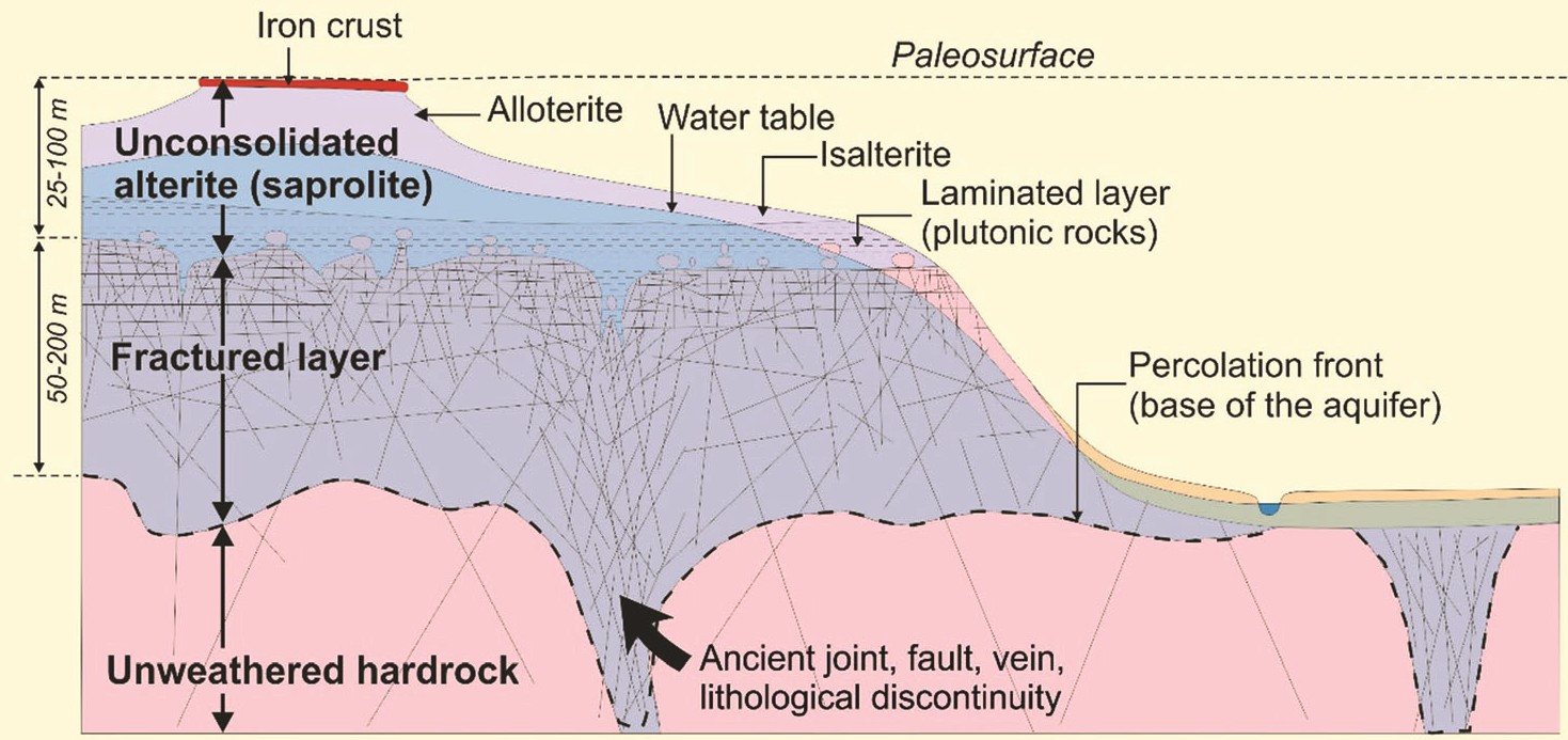
Conceptual model of a fractured granitic aquifer. Image from Lachassagne et al., 2011.
Conclusion & Notes
The values of the physical parameters we measure are influenced not only by the geologic material but also their state, such as saturated vs. unsaturated, or competent vs. fractured.
Note
Can you think of any other states of geologic materials?
There is a middle ground to the "remote" measurement idea: many geophysical methods can be done within a borehole at high resolution. But there are tradeoffs including cost, depth, and spatial extent of the measurements.
In this course we will look at two broad geophysical methods: seismic and electrical. Within each broad category we will see there are variations that can used depending on the geologic purpose of the geophysical survey.
The last phrase of the just above paragraph is important: geologic purpose of the geophysical survey. We are in the business of solving geologic problems (in this course mainly "applied-geologic" problems). If physics can help us, then we learn some (geo)physics. In another case chemistry may help us, and then we learn (geo)chemistry.
Back to the GEOL 420 Homepage.